Thursday, 31 December 2015

Learning what to bring on a trip, or: evolution of my gear

Hiking in northern Spain, 2011 style. 


Learning what to bring on a trip

or 

Evolution of my gear


As I happen to frequently take pictures of all the gear I bring on a trip, I have an overview over how my setup has changed. I haven't been into serious hiking for all too long, but my gear, what kind of clothes and food I bring, has already changed a lot. 

Unfortunately I didn't take any pictures of my gear on the Camino de Santiago I walked in 2011, 2012 and winter 2014. I absolutely don't remember what I brought back then but it would be interesting to know. The only picture I have is the one below, of my cotton packpack ready for the Caminho Português in 2011. It's a 50 liter pack and I hiked in summer... my sleeping bag was way too warm and big. I mean, it doesn't even fit into the pack! 

                                             
Caminho Português 2011


But to be honest, I had no money at all back then and buying a second sleeping bag just because my other one is too big and warm, was not really an option. What else I remember from that trip was that I had long cotton pants that I didn't use a single time, also I walked in a heavy skirt, H&M cardigan and with tennis shoes on. Unsurprisingly I was sweating a lot in my clothes and I had aweful blisters from day one of the trip. It never occured to me though that it was because of my clothes, I just accepted it as it was. 

What else would you wear on a 120km hike? Blundering in september 2011. 
In 2012 hiking for me was all about wearing Nike running gear from head to toe. Way better than H&M cotton.

I know that there's different opinions about this, but I don't think (anymore) that Fjällräven cotton clothes are optimal for glacier hiking, or any hiking really. Too heavy, too bulky, too warm. Sold all of that stuff.
February 2014, Solheimarjokull, Iceland. 


Some years later I finally discovered the existance of hiking gear and clothes that need less than three days to dry after they become sweaty. Still there was a quite limited perspective on what was available, but I think that's perfectly natural when you are just getting in to a new hobby. At first it's always hard to see what you really need, what products are just useless and which are your personal favorites. It's a process of buying, trying it out, selling stuff second hand and starting over. 
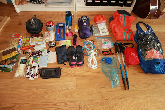
Here's two pictures of my first Kungsleden in summer 2014. Since then I have changed basically everything you can see in this picture. The sleeping bag was colder than sleeping naked, the hiking poles broke right after this trip, the compression bag was incredible heavy and bulky, the water bladder leaked and got permanently green on the inside (blergh...). The gas stove is not bad but very sensitive to wind and quite slow. Why I brought several meters thick rope and a headlamp (midnight sun) is still a mistery to me...
I still have the gore-tex jacket though and it's still awesome, same for the Lifestraw water filter (that you don't need in Lappland though) and my compass. I also still use the first aid kit which I restock accordingly to the trip I'm on. 


Taking a look at the food I brought... it's actually not too bad. It just lacks some fresh stuff and there's definitely too little proteins and fat in the picture. I remember that I was dreaming about cheese, fries and oily stuff. Nowadays I would be bringing a salami, a little bottle of olive oil (I'm not a big fan of butter) and more canned fish. If I had space maybe also some fruit or veggies for the first days.


Here's what I brought on a snowy trip in Jämtland in the end of September 2014. I finally got better hiking poles and a better sleeping bag and sleeping pad. If your sleeping equipment is bigger than your backpack and heavy as a stone, it just can't work out. I also got some durable, light metal cutlery, which I'm still very fond of. 
I still use most of these clothes, besides the gaiters that were not breathable at all and made my legs sweat that much, I could have stepped as well in any puddle around. After this trip I swapped out my drinking bottle for a Nalgene. The aluminum bottle from Sigg was freezing every night and ended up leaking all over my sleeping matress which willingly sucked up half a liter of water. Not so nice in a cold night...


In March 2015 I went skiing on Kungsleden and spent a week in Abisko. I didn't camp though, so my packing doesn't include a kitchen or a sleeping pad. I still think that this is quite a good setup and I would bring basically the same on a similar trip. Of course I also brought skiing boots, they're just not in the picture. The sneakers I brought are a bit too heavy and in the meanwhile I got some secondary shoes that I can wear indoors or just for going to the outhouse that are less than half the weight of these. I sold some of my sweaters and ski underwear on a flea market in summer and substituted them by merino wool products. Wool is just the warmest and most comfortable material. 
The sleeping bag felt a bit too heavy for me, with 1,6kg. I recently sold it and ordered a new one from Roberts.pl that will be only about 800 grams while having the same comfort temperature. 


In June 2015 I went for a two week camping trip in Lappland again. There was so much snow left that we went on snowshoes, it was actually not that different from March...
I try to bring all my socks and underwear in wool and go lightweight. The Smart Wool socks are so warm, fast drying and never start smelling, that it's enough to bring two pairs for the whole trip. One pair that I wear during the day and one pair for the evening and night. 
The crampons and the Therm-a-rest didn't make the cut and I left them at home. 

A look into the Trangia kitchen. The idea is to fill out all small spaces and bring just as much as needed. There's no need to bring more detergent or more than half a sponge for washing the dishes. 
Around the cooking pot you can see all other kinds of stuff I brought. I don't save on lighters, matches and a fire steel. 


I'm being realistic though and know that in a couple of years I will look back at these pictures and think 'was I crazy?'. Or just imagine how it will be, looking back twenty years from now!?
Picking gear and equipment, improving it, changing it,... is really just one of my hobbies and I think it's a lot of fun. I'm not regretting any of the "poor" choices I've made in the past, all of the blisters I got from Lidl socks and pain I had from my too heavy backbacks. I think it's interesting to evolve and be able to look back to see where you've come from. 

Friday, 18 December 2015

Nordkapp to Grövelsjön. 1800km, 110 days.

You can find an updated version of this guide HERE


A plan for the summer of 2016: Nordkapp to Grövelsjön


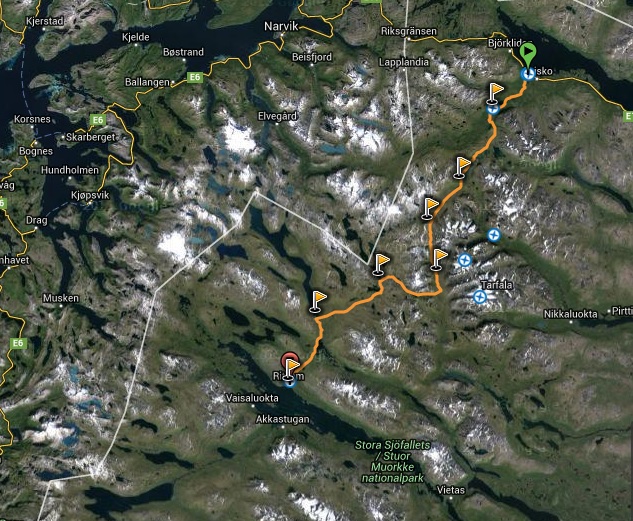
I researched and looked at maps during the last weeks and here are the possible stages for a combination from Gröna Bandet, Nordkalottleden, nortnernmost part of E1 (European Long Distance Footpath Norkapp to Sicily), Kungsleden and Norge på Langs:

All the parts that I have described in stages here are together around 1500km. That's already a bit. With the undecided part in the middle it will be about 1800km total, I suppose. If I walk an average of 20 kilometers a day (not calculating rest days), the whole thing will take 90 days. That doesn't even seem that much. I want to start as early as possible, of course. I will have to be patient and wait till the north is free of snow, but the areas close to the ocean should be walkable from the middle of June. 
If I start by the middle of June and give myself time till the end of September I would have 110 days, so 20 days extra (and I will need those cause I can't walk 20k everyday, unless I become incredibly strong and fit). Even without the stages between Kittelfjäll/ Grannes and Åre, I already have 86 stages, according to the plan above. That's cause some are 30km+ while others are under 10 kilometers. 

Besides that I could always make the trip faster by going the bigger part in Sweden and not in Norway. I think that the part between Sälka, where I leave Kungsleden, and Grannes, where I think about going to Kittelfjäll, would take me about half of the time, if I just continued on Kungsleden. It's much less kilometers, less elevation and an easy to follow, flat trampled trail. 
But if it was all just about taking the easiest, shortest, most convenient way and "saving time"- well, then I can just stay at home instead. 

Bold words mean places where I can restock on food or at least buy a meal. There won't be too many of those during the first part of the trip...
Of course I will camp all along the trip and only occasionally sleep in a hut. I still orientated my daily stretches to huts, for the sake of having a point of reference. 

Nordkapp to Kautokeino / 330km

  1. Nordkapp -> Skarsvågskrysset 13km / no supplies / no accomodation Start off with food for about ten days, and buy some extra on stage 6, 11 and 13
  2. Skarsvågskrysset -> Veidneset 19km / no supplies / no accomodation
  3. Veidneset -> through the Nordkapp tunnel to Vesterpollen. Depending on the traffic...
  4. Vesterpollen -> Vardancohka 25km / no supplies / Very basic hut with space for 2 persons along the E1-route. No oven.
  5. Vardancohka -> Stohpojohka 26km / no supplies/ Open reindeer herder hut with 4-5 beds. There's a stove but not always firewood. 
  6. Stohpojohka -> Hattir Ost 22km / supplies and accomodation 5km from the trail: Olderfjord hotell Russenes Caming (private) Open in summer season. 29 roomas and 14 huts. Includes retaurant. A bit south of Olderfjord there is a Statiol gas station that has a fair sortiment of food. The shop closes at 7pm. Transport: Bus towards Russenes passes the parking Hattir Øst  kl 16 20. More info: www.olderfjord.no/en/home Tlf.: + 47 78 46 37 11
  7. Hattir Ost -> Duolbajarcopma 33km / no supplies / no accomodation
  8. Duolbajarcopma -> Bastingammen 23km / no supplies / no accomodation (small hut is closed?)
  9. Bastingammen -> Rukkujavri 24km / no supplies / no accomodation
  10. Rukkujavri -> Bojobeaskihytta 21km / no supplies/ Bojobeaskihytta (Alta Turlag) Locked with a DNT standard key, 8 beds. 
  11. Bojobeaskihytta ->  Mollesjohka Fjellstue 32km / 54 beds, food available but best to be ordered beforehand. 
  12. Mollesjohka Fjellstue -> Ragesluoppal 17km / no supplies/ simple hut with 4 beds.
  13. Ragesluoppal -> Masi 26km / Masi Turistsenter (private) Renting out huts, closes at 7pm. Warm meals can be bought in the café. There is a store next to the church. 
  14. Masi -> Biggejavri 20km / no supplies / no accomodation
  15. Biggejavri -> Mierojavri 27km / no supplies / no accomodation
  16. Mierojavri -> Kautokeino 17km / Food and a soft bed! Buy resupplies for the next 10 days or have a box with food sent from home.                                                                                                            
                                    

  Kautokeino to Kilpisjärvi / 190km                                                                                                 

  1. Kautokeino -> Cunovuohppi 18km / Madam Bongos fjellstue (private) several huts to rent Tlf.: 481 06 003 Meals can be bought. 
  2. Cunovuohppi -> Reisavannhytta 30km / no supplies / Reisavannhytta (Statskog) Locked hut with 6 beds. Booking over inatur.no 
  3. Reisavannhytta -> Nedrefosshytta 30km / no supplies / Nedrefosshytta (Troms Turlag) Hut with 16 beds, locked with DNT standard key. 
  4. Nedrefosshytta -> Saraelv 28km / no supplies / Ovi Raishiin, Gammetunet Hut with 4 beds, locked with DNT standard key. 
  5. Saraelv -> Somashytta 31km / no supplies / Somashytta (Statskog) Open hut with 6 beds. 
  6. Somashytta -> Pitsusjärvi 15km / no supplies / Open hut with 12 beds. Simple standard, oven, wood. 
  7. Pitusjärvi -> Meekonjärvi 10km / no supplies/  Open hut with 6 beds. Simple standard, oven, wood. 
  8. Meekonjärvi -> Kuinarjohki 10km / no supplies/  Open hut with 14 beds. Simple standard, oven, wood. 
  9. Kuinarjohki -> Saarijärvi 10km / no supplies /  Open hut with 10 beds. Simple standard, oven, wood.  
  10. Saarijärvi -> Kilpisjärvi 15km / Kilpisjärven Retkeilykeskus (private) Rooms and huts for rent. Restaurant, kitchen and supermarket.
Have food sent from home to the Hiking Center www.kilpisjarvi.info     


Kilpisjärvi to Abisko / 190km

  1. Kilpisjärvi – Treriksrøysa – Goldahytta 15km / no supplies / Goldahytta (Troms Turlag) Hut with 22 beds, locked with DNT standard key. 
  2. Goldahytta -> Gappohytta 13km / no supplies / Gappohytta (Troms Turlag) Hut with 20 beds, locked with DNT standard key. 
  3. Gappohytta -> Rostahytta 20km / no supplies/ Rostahytta (Troms Turlag) Hut with 33 beds, locked with DNT standard key. 
  4. Rostahytta -> Daertahytta 17km / no supplies/ Dærtahytta (Troms Turlag) Hut with 24 beds, locked with DNT standard key. 
  5. Daertahytta -> Dividalshytta 24km / no supplies/ Dividalshytta (Troms Turlag) Hut with 20 beds, locked with DNT standard key. 
  6. Dividalshytta -> Vuomahytta 18km / no supplies/ Vuomahytta (Troms Turlag) Hut with 20 beds, locked with DNT standard key. 
  7. Vuomahytta -> Gaskashytta 17km / no supplies/ Gaskashytta (Troms Turlag) Hut with 20 beds, locked with DNT standard key. 
  8. Gaskashytta -> Altevasshytta 12km / no supplies/ Altevasahytta (Troms Turlag) Hut with 17 beds, locked with DNT standard key. 
  9. Altevasshytta -> Lappjordhytta 24km / no supplies/ Lappjordhytta (Troms Turlag) Hut with 164beds, locked with DNT standard key. 
  10. Lappjordhytta -> Abisko Turiststation 25km / Food, a restaurant, a shop a warm bed! Have food sent from home to STF Abisko Turiststation
     

Abisko to Ritsem / 115 km                                                        

  1. STF Fjällstation Abisko -> Abiskojaure 15km / shop in Abiskojaure huts, sauna
  2. STF stuga Abiskojaure -> Alesjaure 20km / shop in Alesjaure huts, sauna
  3. STF stuga Alesjaure -> Tjäktja 13km / no shop in the hut
  4. STF stuga Tjäktja -> Sälka 13km / shop and sauna
  5. STF stuga Sälka -> Hukejaure 25km / no shop in the hut
  6. STF stuga Hukejaure -> Sitasjaure 19km / no shop in the hut
  7. STF stuga Sitasjaure -> Ritsem 22km Have food sent from home to STF Ritsem Turiststation    
 

Ritsem to Sulitjelma / 115 km                   

  1. STF Fjällstation Ritsem boat to Akkastugorna 
  2. STF stuga Akka -> Kisuris 14km 
  3. Kisuris -> Låddejåkka 23km / little shop by the hut and in the Sámi village
  4. Låddejåkka -> Arasluokta 13km / little shop by the hut and in the Sámi village
  5. Arasluokta -> Staloluokta 12km / little shop by the hut and in the Sámi village
  6. Staloluokta -> Staddajåkkå 12km / no shop in the hut
  7. Staddajåkkå -> Sårjåsjaure 6km / no shop in the hut
  8. Sårjåsjaure -> Sorjushytta 19km / no shop in the hut
  9. Sorjushytta -> Ny-Sulitjelma Fjellstue 16km/ Buying food in Sulitjelma or in Fauske
   

Sulitjelma to Lønsdal / 90 km                               

  1. Sulitjelma -> Lomihytta 5km / no shop in the hut
  2. Lomihytta -> Calalveshytta 12km / no supplies/ Calalveshytta (Sulitjelma og OmegnTuristforening) Hut with 25 beds, locked with DNT standard key. 
  3.  Calalveshytta -> Coarvihytta 12km / no supplies / Coarveshytta (Sulitjelma og OmegnTuristforening) Hut with 4 beds, locked with DNT standard key. 
  4. Coarvihytta -> Balvasshytta / 20km / no supplies / Balvasshytta (Sulitjelma og OmegnTuristforening) Hut with 4 beds, locked with DNT standard key.
  5. Balvasshytta -> Argaladhytta 10km / no supplies/ Argaladhytta (Bodø og Omegns Turistforening) Hut with 7 beds, locked with DNT standard key.
  6. Argaladhytta -> Trygvebu 8km / no supplies/ Trygvebu (Bodø og Omegns Turistforening) Hut with 20 beds, locked with DNT standard key.
  7. Trygvebu -> Graddis Fjellstue 8km / Graddis ligger øverst i Junkerdale ikke langt fra svenskegrensa. Her passerer Grensesømmen og det er fjellstue, camping og vandrerhjem. Stedet har helårs bilvei. Overnatting i lavsesong bare etter forhåndsbestilling. Telefon i sesong: 75 69 43 41
  8. Graddis Fjellstue -> Lønstua 15km / Restaurant in Saltfjellet Hotel Polarsirkelen Lønstua (Bodø og Omegns Turistforening) Hut with 30 beds, locked with DNT standard key. Get food sent from home to Saltfjellet Hotel
 

Lønsdal to Umbukta Fjellstue / 140 km

  1. Lønstua -> Saltfjellstua 24km / no supplies / Saltfjellstua (Rana Turistforening) Hut with 20 beds, locked with DNT standard key.
  2. Saltfjellstua -> Krukkistua 5km / no supplies / Krukkistua (Rana Turistforening) Hut with 8 beds, locked with DNT standard key.
  3. Krukkistua -> Bolnastua 27km / no supplies/ Bolnastua (Rana Turistforening) Hut with 13 beds, locked with DNT standard key.
  4. Bolnastua -> Virvasshytta 27km / no supplies/ Virvasshytta (Rana Turistforening) Hut with 16 beds, locked with DNT standard key.
  5. Virvasshytta -> Kvisteindalstunet 23km /no supplies/ Kvitsteindalstunet (Rana Turistforening) Hut with 10 beds, locked with DNT standard key.
  6. Kvisteindalstunet -> Sauvasshytta 23km / no supplies/ Sauvasshytta (Rana Turistforening) Hut with 9 beds, locked with DNT standard key.
  7. Sauvasshytta -> Umbukta Fjellstue 12km / Café, restaurant, accomodatio year round. Booking: 951 951 31 / 957 990 58 Get a box with food from home to Umbukta Fjellstue


Umbukta Fjellstue to Unkervatnet Camping / 110 km

  1. Umbukta Fjellstue -> Kjennsvasshytta 12km / no supplies/ Kjennsvasshytta (Hemnes Turistforening) 28 beds
  2. Kjennsvasshytta -> Gressvasshytta 12 km / no supplies / Gressvasshytta (Hemnes Turistforening) 14 beds
  3. Gressvasshytta -> Steikvasselv Gård 12km / Meals and supplies are available but must be booked beforehand  Tlf.:  +47 916 70 540/ +47 915 56 282
  4. Steikvasselv -> Sivertgården 21km / no supplies/ Sivertgården (privat) Accomodation to be booked beforehand Tlf.: +47 75 18 51 43
  5. Sivertgården -> Krutvatnet 20km / no supplies/ Krutvasshytta (Statskog) Åpen, 4 beds
  6. Krutvatnet -> Tverrelvnes 22km / no supplies/ Tverrelvnes (privat) 12 beds.
  7. Tverrelvnes -> Unkervatnet Camping 12km / no supplies/ Grannes Camping (privat) 12 Huts with 2 to 6 beds each.

I haven't decided yet how to continue after Grannes Camping. If I continue in Norway I will come to a stretch without any resupplies and without a marked trail for about 300km. Grannes Camping is right next to the roas that goes over to Sweden. Where I could continue on a trail from Kittelfjäll to the south. But even here I will come upon an inconvenient stretch, south of Gäddede I will basically have to walk on the road for a really long time. 
I'm happy for any suggestion how to get past this stretch in the fastest and most comfortable way. 

From Åre to Grövelsjön / 200 km

  1. Åre -> Vålådalen about 30km street
  2. Vålådalen -> Stensdalen 13km/ STF hut with supplies
  3. Stensdalen -> Gåsen 16km / STF hut with supplies 
  4. Gåsen -> Helags 18km / STF Fjällstation with sauna, restaurant,..
  5. Helags -> Fältjägaren 12km / STF hut with supplies 
  6. Fältjägaren -> Ramundberget 16km / Youth Hostel with supplies
  7. Ramundberget -> Tänndalen 20km / Youth Hostel with supplies
  8. Tänndalen -> Skedbro 21km / STF hut with supplies 
  9. Skedro -> Rogen 17km / STF hut with supplies 
  10. Rogen -> Storrödtjärn 17km /  STF hut with supplies 
  11. Storrödtjärn -> Hävlingen 9km / no supplies (as if this would matter at this point...)
  12. Hävlingen -> Motherfuckin' Grövelsjön! 13km


Two good old STF maps that have unfortunately been taken offline when they renewed their website.

Sunday, 13 December 2015

Dreaming about next year's big hike

The incredible feeling of finishing a trail, of coming to the top. 


Now in December the days are short and dark. The best thing, especially at work, is to dream about my plans for next year. At this point I don't want to call it "planning" yet, cause I still haven't decided for a specific hike. 
A big inspiration for me is the norwegian adventurer Lars Monsen, who has spent years of his life in the Scandinavian wilderness. I recently got two of his books and especially the story about his year long hike through Norway is an absolute inspiration. In 1988 he and his friend Trond decided to walk along the Norwegian border, all the way from Russia to the south of the country. Even considering that the conditions have changed a lot since then, the book gives me the awesome feeling that I can make happen anything that I dream about. 

Mixing up languages- one in German one in Norwegian

 I can't even say what attracts me so much about a long hike. I guess it's the feeling of adventure, of doing something unusual, outside of the time frame of a normal holiday. Also it's the concept of "holiday" that I don't like. Holiday is a week or so to take a rest and get a break from work in order to relax. What I want to do is (at least in my mind) not a holiday. It's not an expedition either, since others have done it before, it's an adventure, a task that I give myself, an experience I want to have in my life. 

Of course I can't even be sure I will stick to my plan. What if I get tired of walking? If I start to feel bored, worn out, if my body hurts, if I feel lonely or lost? 
I know all these things can and most of them will happen, to some extend at least. What I will try is to overcome the negative feelings, wait it out, see if it gets better and maybe afterwards realize how overcoming these problems made me stronger. 

Even giving up before finishing the hike is of course a possibility but I will try to avoid that, of course. One thing that can help to overcome situations in which I will want to give up is for instance this blog, or signing up for an "official" hike, such as Gröna Bandet or Norge på Langs. Knowing that there is something specific to archieve, that I can count the kilometers backwards to point X and that some people are virtually following my trip is definitely a huge motivation. 
Other than that, signing up for anything seems a bit pointless of course, since I would need to follow specific rules, which takes away a part of the freedom of the hike. But because of the motivational aspect I will probably still do it. 


Wednesday, 9 December 2015

Winter! Winter?

Snow, rain and a weird colored sunset. This afternoon.


Yes, what's happening to the winter weather? Today and yesterday were more like days in late spring: rain, melting snow,... Way too warm temperatures. 
So I decided to drive home already tomorrow, one day earlier than planned. Simply because skiing or any other outdoors activity simply sucks right now. 

Yesterday I still went 25km on my backcountry skis though and today I was out in the darkness and had a nice fire with another girl who stays here. 
Oh, and I also built two amazing snowmen (one is a snow girl, the one with my hat on,) 


As you can see from the stats I'm a terrible skier and I will have to change my technique radically if I want to participate in next year's Kortvasan, which is 30km. 
For all non-swedes: Kortvasan is the short version of the 90km skiing race Vasaloppet, which takes place in Mora, every year in March. I signed up for the shorter version and now I'm going to have to bite my way through it. 
Sometimes I don't even know why I do these things and put myself in trouble ;)


And here norwegian adventurer (and my personal idol) Lars Monsen with my last words for today: 


Monday, 7 December 2015

A windy day in the forest.

I'm still amazed places like this exist on earth.
This morning I woke up to the sound of the trees swaying around and small branches flying against the window. It was definitely too windy to try to go higher up on the mountains, above the treeline. In the mountain station there is a cool weather station and some information about wind chill factor. For some reason I'm a real nerd when it comes to weather oberservation and I love the automatic calculation of the felt temperature. 
(The minimum temperature doesn't show on this picture. It changes between the measured temperature and how long ago this was measured)

Here's some more about the effective/felt temperature

I tried some x-country skiing, but the tracks were ruined by the wind and melting of the last days. 

great.

Later on I went backcountry skiing in the forest and tried to take a little video of it. It's not exactly action sports, so consider it a relaxation video ;). My skiing, which is otherwise of course perfect, got a little bit worse by holding my phone in one hand all the time. I had both skiing poles and both gloves in the other hand and basically nothing to push or balance myself. So all mistakes or any whacky style you see is of course only due to that. 

So here it is, my first (shaky) video: 


And some more pics of the amazing midwinter light! 


STF mountain station

Everything on the other side of the lake is Norway.

Another untimely sunset at 14.30 pm. 


Sunday, 6 December 2015

A lot of reindeer and a bit of skiing


This morning I woke up to a beautiful sunrise and no cloud in the sky. I got ready quickly, to not miss any of the daylight and got my equipment from the car. Such a nice feeling to stand on the skis again! 
As soon as I got away from the cross country track though the snow showed it's true face and it was a crust of ice with some melted slush underneath. Needlees to say it was very very hard to go uphill in these conditions. I have no skins on my skis (because I don't own any) and it felt a lot like going on an escalator that goes the wrong way. After about 45 minutes I looked back and I realized that I wasn't going anywhere. So I decided to drop my plans of getting to the top of Jakobshöjden for today. The way down took me about three minutes.
As I was already rushing downhill, I continued to the nearby lake and then up again to the mountain station. 


I drove to Idre, which is 40km away, to look for some skins, fuel the car and do some shopping. On the way I encountered at least a hundred reindeer that were licking the salt of the street. They are completely crazy about the salt that is used by the snowplow in order to make the road less slippery! Some moved away as the car approached, others couldn't resist and continued to lick the asphalt, even as I was half a meter away. I got out of the car several times just to look at them. One even came to me and sniffed on my hand. Unfortunately for the reindeer my hands were not salty.


would you guys mind to move a little? 

Nipfjällsjugan

"Got some salt?"

Sámi flag, as Idre is Sweden's southern most part of Sápmi

Storsätern Kapell

3 pm sunset over the STF Fjällstation

Saturday, 5 December 2015

The first snow!

...At least the first snow for me this winter. 

After some 8 hours of driving I came to Grövelsjön Fjällstation, where I'll stay for some days enjoying the cold and the snow. So far the weather hasn't been all too winterly. Along the way it was mostly storm, rain and melting snow. Even up here, on 62º North and 800m over sea level it's 3ºC positive right now, and that in the middle of December. I hope for it to become colder soon. 

Here are some first impressions:


On the way the street conditions were not really fun. It was actually kind of terrifying. I have aboslutely no problem with driving on snow, but slushy ice and a lot of rain falling on top is not really in my comfort zone. Saw a guy putting on snow chains and I think it might have been a good idea. At least my car has some studded tires that make it a bit less slippery. I'm already dreading the way back home next friday :P


But now no more driving and enjoying the coziness :)


Plans for tomorrow are to make a topptur. It looks like it should be sunny and depending on the snow conditions I will take my backcountry skis, or maybe just winter boots. I might put crampons in my backpack, in case it gets really icy and steep. Thinking about Storvätteshågna (1204 m, Dalarna's highest peak), or alternatively Jakobshöjden, which is closer and about 1100m high. 
It would be awesome to get a view over the snowy landscape on my first proper day here! I hope there will be no clouds or fog. Doesn't look impossible, maybe just a little bit windy.